


– Identify the location of house and driveway in lot
– Identify disturbed area
– Identify impervious area
– Create setback lines as per code compliance
– Annotate construction easement & drainage easement
– Identify FFE (Finished Floor Elevation)
– Create grading of 3:1, 2:1 or flatter
– Create propose retaining wall, if necessary
– Mass grading for Existing area
– Design detention/retention pond
– Create lot/parcels
– Create surface on existing topo survey data
– Prepare as built GPS submittal for Department of Transportation
– Prepare geographic features in shapefile for points, lines, polygons (areas) with attribute tables
– Prepare Structures shapefile for Storm, sanitary sewer, water line devises
– Prepare Conveyances shapefile for the trench, swale, pipe culvert, ditch, circular pipe
– Prepare Polygons shapefile for rip rap zone and any specific area
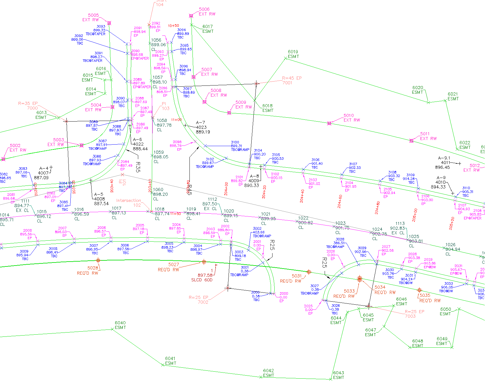
– Create Alignment
– Georeferencing of Cad File
– Create Feature Line Attach construction layout/Mainline plan with Cad file to verify exploded cad data.
– Create points (PNEZD file) and worksheet for following construction elements
– Volumetric Surface Creation for Grading
– Grading Creation for value engineering
– Estimation of highway and road construction project
– Estimation for specialty contractor such as concrete, retaining wall, striping, signal & light installation
– Calculate Water Quality Volume
– Water Storage Design as per impervious area
– Sediment Storage Design as per disturbed area
– Propose BMP structures as per requirement of code compliance
– Dimension calculations of propose erosion control devices.
– Propose dust control on disturbed area if require
– Propose grassing slope stabilization
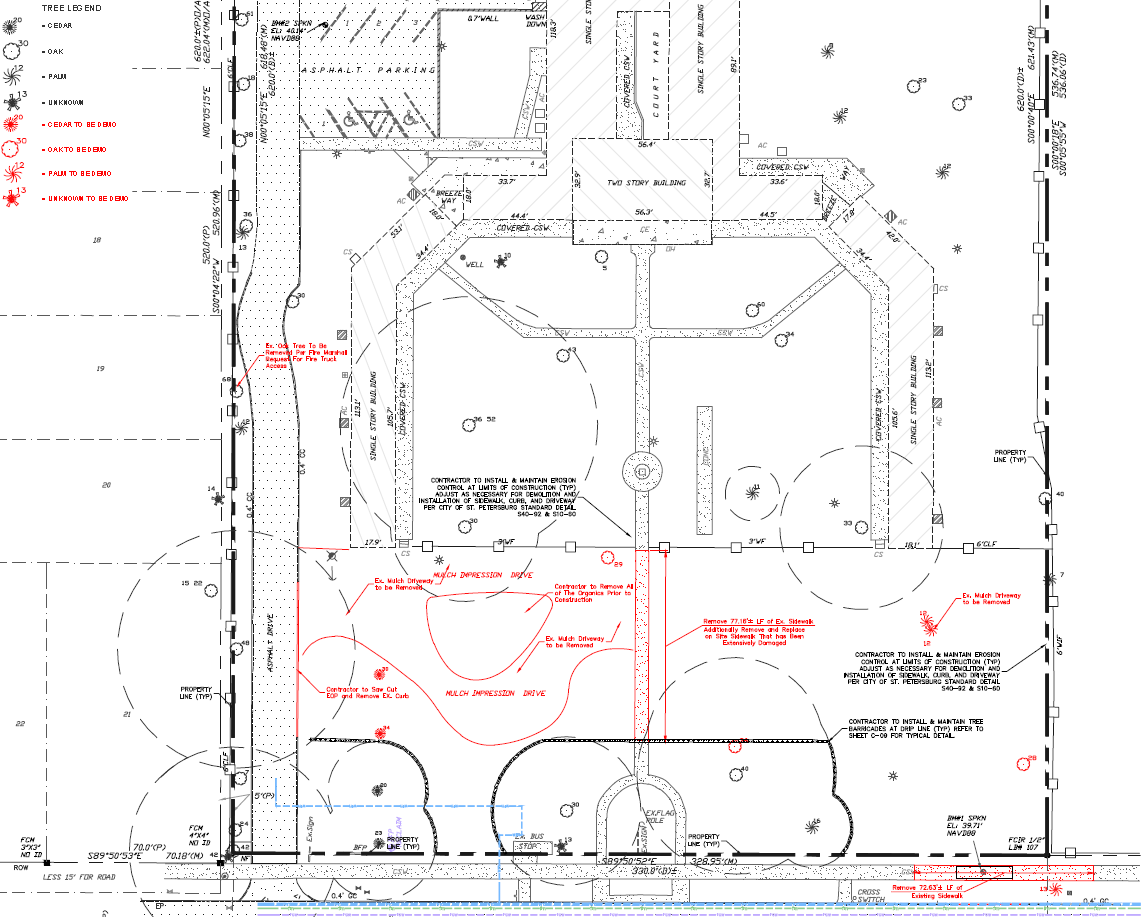
– Tree calculations
– Preparation of highway demolition plan
– Sanitary sewer system
– Storm water management system
– Parking lot
– Road widening with utilities
– Roundabout and intersection design
– Cover sheet
– Index
– General notes
– Typical section
– Summary of quantities
– Construction layout Mainline roadway plan and profile
– Cross sections
– Driveway profile
– Special grading plan
– Drainage area map and profile
– Utility and lighting plan
– Signing and marking plan
– Special construction details
– Prepare and Submit Temporary Traffic Control Plan at per MUTCD
– Identify the location of house and driveway in lot
– Identify disturbed area
– Identify impervious area
– Create setback lines as per code compliance
– Annotate construction easement & drainage easement
– Identify FFE (Finished Floor Elevation)
– Create grading of 3:1, 2:1 or flatter
– Create propose retaining wall, if necessary
– Mass grading for Existing area
– Design detention/retention pond
– Create lot/parcels
– Create surface on existing topo survey data
– Prepare as built GPS submittal for Department of Transportation
– Prepare geographic features in shapefile for points, lines, polygons (areas) with attribute tables
– Prepare Structures shapefile for Storm, sanitary sewer, water line devises
– Prepare Conveyances shapefile for the trench, swale, pipe culvert, ditch, circular pipe
– Prepare Polygons shapefile for rip rap zone and any specific area
– Create Alignment
– Georeferencing of Cad File
– Create Feature Line Attach construction layout/Mainline plan with Cad file to verify exploded cad data.
– Create points (PNEZD file) and worksheet for following construction elements
– Volumetric Surface Creation for Grading
– Grading Creation for value engineering
– Estimation of highway and road construction project
– Estimation for specialty contractor such as concrete, retaining wall, striping, signal & light installation
– Calculate Water Quality Volume
– Water Storage Design as per impervious area
– Sediment Storage Design as per disturbed area
– Propose BMP structures as per requirement of code compliance
– Dimension calculations of propose erosion control devices.
– Propose dust control on disturbed area if require
– Propose grassing slope stabilization
– Tree calculations
– Preparation of highway demolition plan
– Sanitary sewer system
– Storm water management system
– Parking lot
– Road widening with utilities
– Roundabout and intersection design
– Cover sheet
– Index
– General notes
– Typical section
– Summary of quantities
– Construction layout Mainline roadway plan and profile
– Cross sections
– Driveway profile
– Special grading plan
– Drainage area map and profile
– Utility and lighting plan
– Signing and marking plan
– Special construction details
– Prepare and Submit Temporary Traffic Control Plan at per MUTCD